Working groups
On this page
- WG1: Classification and Retrieval of Biological Data from European Weather Radars
- WG2: Improvement of Weather Radar Data Quality and Validation of Biological-classification Algorithms
- WG3: Visualizing Spatio-temporal Patterns of Animal Movement
- WG4: Significance and potential of Animal Movement Research
ENRAM will achieve its scientific goals through the formation of four interdependent Working Groups (WG) which will last for the duration of the Action.
The WGs are interdependent on each other and so there will be consistent dialogue and frequent meetings between all WGs to enable exchange of information. The WGs will coordinate the publishing of joint research results in scientific journals and at scientific and stakeholder related conferences.
WG1: Classification and Retrieval of Biological Data from European Weather Radars
Working group leader: Adriaan Dokter
WG1 will assess and evaluate biological-classification algorithms on data from the European weather radar network, with the ultimate aim of ensuring consistent high-quality spatio-temporal information on animal movement intensity in the aerosphere above the whole of Europe and improving the quality of meteorological outputs.
At the first stage, data which is already collected from a few weather radars will be processed with the basic algorithm, reviewed and approved. Experts will assess output in joint meetings and determine whether specific modifications are needed for different areas in order to work towards optimised versions of the algorithm tailored to fit the specifications of individual weather radars. Refined bird algorithms will then be rolled-out across the entire network. National meteorological institutes will be motivated and supported to implement the algorithm for automated and routine data processing.
Later stages will focus on setting up protocols to coordinate research performed independently from the COST Action, by the single group members.
The status of data availability within OPERA and ENRAM can be viewed here: https://github.com/adokter/vol2bird/wiki/Radar-data-requirements-and-availability-for-ENRAM
WG2: Improvement of Weather Radar Data Quality and Validation of Biological-classification Algorithms
Working group leader: Felix Liechti
WG2 will provide data from groups currently monitoring aerial movement to ‘ground-truth’ (i.e. calibrate) the biological aspects of the weather radar data, and to validate the biological-classification algorithms produced in WG1.
WG2 will coordinate and stimulate cross-calibrations of different dedicated biological radars and the weather radar network, with respect to their capabilities of detecting and classifying a broad range of animal taxa in the aerosphere (insects, birds and bats). This knowledge will form the basis of the evaluation of the suite of biological classification algorithms by WG1.
They will first link research groups to conduct comparative analysis of pre-existing data from dedicated biological radars (for birds and insects), and pre-existing data from operational weather radars that is believed to represent various biological targets (birds and insects).
Then they will create a platform for the organization of a cross-calibration measurement campaign, involving the simultaneous deployment of multiple remote sensors within the sensed volume of an operational dual-polarisation weather radar. The remote sensors to be deployed will include as many existing systems as possible (e.g. air traffic surveillance radar, ornithological radar, entomological radar, thermal imaging equipment, LIDAR (Laser Imaging Detection And Ranging), acoustics for flight call identification, etc.).
And finally they will assure and evaluate validation of the first roll-out of the ‘refined bird-algorithm’ across the weather radar network, and investigate the potential of the more advanced classification-algorithms to produce high-quality quantitative data on the complete set of potential target animals.
WG3: Visualizing Spatio-temporal Patterns of Animal Movement
Working group leader: Hans van Gasteren
WG3 will use data produced by the weather radar network to quantify spatio-temporal patterns of aerial animal movements at different scales in space and time.
The following activities will be the focus of WG3:
- Evaluation of infrastructure for efficient storage and retrieval of biological information extracted from weather radars in close cooperation with OPERA.
- Fostering collaboration between computational scientists and biologists to design infrastructure for efficient visualization of biological information extracted from weather radars and the most relevant environmental factors.
- Mapping animal movement at large scales (across multiple radars).
- Evaluation of statistical modelling approaches to quantify the influence of atmospheric dynamics on animal movement (local to continental).
- Investigating the degree of spatio-temporal correlation between radar sites for different movement patterns and taxa and the causal factors underlying the large-scale patterns.
WG4: Significance and potential of Animal Movement Research
Working group leader: Ommo Hüppop
WG4 will review current knowledge and work out new and hitherto unanswerable research questions related to continental-scale animal migrations through the aerosphere, and define grand challenges and priorities to steer future research conducted by Action members.
They will evaluate the needs of the stakeholder communities as well as assess the applicability of recent findings in research and explore new research possibilities that will emerge from the previously unattainable data. By its very nature, the tasks of this WG are somewhat speculative at the moment, as many more ideas will surely emerge following results from other WGs. The activities of this WG will be re-evaluated by the MC during the course of the Action.
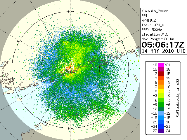 In Helsinki, Finland, Kumpula weather radar reflectivity on the 14th of May, 2010, 05 to 17 UTC. The radar in the centre is roughly on the northern coast of the Gulf of Finland. Precipitation is in the topmost class, while other reflectivity was due to masses of birch aphids migrating over the Gulf of Finland northwards. Reflectivity caused by insects varied due to horizontal roll vortices over the land area in Finland, and by the gust front disturbances caused by the thunderstorms. Differences in the insects’ number density in air are the primary reasons for the features in reflectivity, but measurement volume gets also higher with range, and both the convergence and upward motions contribute to the patterns.